
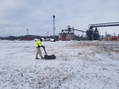
GPRS Locates Utilities on 60+ Acre Lot for Environmental Testing
Ground Penetrating Radar Systems (GPRS) was recently called out to a project by an environmental company to locate underground utilities for a project on a 60+ acre lot inside of an active coal mine. The scope of the project was to locate any and all underground utilities for almost 50 soil boring sample locations to be drilled down 25+ feet. By using GPR and Radio Detection, GPRS was able to safely clear each specific location of any obstructions or impediments in the ground that could become dangerous while drilling. GPRS marked underground utilities and included depths of the lines located underground as well. Ground penetrating radar and Radio Detection is an accurate and effective way of locating underground utilities, vaults, tunnels, and other obstructions prior to any ground excavation. This project was a vital first step for the environmental company to ensure the safety of all employees, and also helped establish a clearer timeline that avoids stoppages due to utility strike incidents.
The scheduling of the project went extremely smooth for all sides, and the underground utility locating performed by one technician for simplicity and best communication practice as well. Why would you risk digging underground without knowing where any utilities are in your designated area when GPRS has the ability locate and mark all utilities with depth indications for your safety!
The images to the right show some of the processes that lead to utilities being located on site.
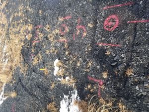
Below is a second photo displaying a an unknown utility line running next to a proposed soil boring location.
GPR Equipment Used:
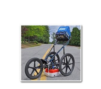
Ground Penetrating Radar (GPR)
GSSI SIR – 3000
- GPRS uses a Geophysical Survey Systems Inc. (GSSI) SIR-3000 Radar unit. This is the most advanced GPR available. It allows for onsite interpretation, as well as stores data for later processing. This equipment is self-calibrating, allowing more precise depth and location measurements.
400 MHz Antenna
- This antenna typically allows data collection to a depth of approximately 3’- 6’, with a maximum capability up to 12’ depending on soil conditions. This specific antenna was created and calibrated specifically for locating underground utilities, UST’s, and other underground anomalies.
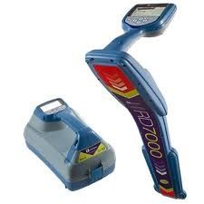
Radiofrequency Detection System (RD)
RD 7000+
- This is an electro-magnetic tone locating device manufactured by Radio Detection. This specific model detects live power and RF signals underground, allowing us to locate electrical or telephone lines even if they are below the minimum size requirements to be detected by GPR. It also allows us to detect utilities via induction or conduction with an exposed or known surface of the utility.
For more information on how GPRS, Inc. can help you on your next project, please contact Colin Broughton at 216-379-4660 or by email at colin.broughton@gprsinc.com. We also have the capabilities of locating conduits, rebar, and post tension cables in a concrete slab.