
What to expect when calling GPRS
THE NATION’S LARGEST GPR LOCATING COMPANY
![photoscreen-12.41.56[07.10.2019].png](https://static.spacecrafted.com/ade5be42296f44a6abd280d5cfcb8a2c/i/c4df3bcdb2cb4c82974f1939107671e3/1/4SoifmQp45JMgBnHm9g4L/photoscreen-12.41.56%5B07.10.2019%5D.png)
Ground Penetrating Radar Systems of Pennsylvania
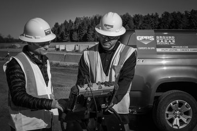
Hired by clients large and small, GPRS is the leading choice for concrete scanning and utility locating in Pennsylvania, and around the Nation. Since many private utilities remain unmarked even after calling your local 811 One Call System, we pick up where they left off by locating any and all underground utilities and any other subsurface impediments prior to excavation, saw cutting, or general construction.
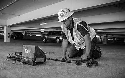
GPRS can locate private and public underground utilities throughout Pennsylvania including water, electric, gas, communication, storm, and sanitary sewer. We also locate subsurface material in concrete such as conduit, rebar, and various reinforcement in the concrete slab, as well as detecting concrete slab thickness. GPRS offers pipe inspection via our CCTV division, and locating underground structures such as foundations, grave sites, and underground storage tanks (USTs) with industry leading equipment.
When clients hire GPRS, they have the peace of mind of knowing that they have the most reliable scanning technology on their job site and they'll receive the assistance of a technician who can provide them with the most accurate data. For over a decade, GPRS has been the industry leader by providing outstanding service and cutting edge technology, keeping projects on time, reducing safety risks, and putting our relationships with our clients before profit. We offer Google Earth overlays, CAD documents, EMI (electromagnetic induction) reports, as well as written reports showing GPR data and jobsite photographs. Depending on a customer’s needs, we will provide the necessary deliverables. Please note that we do not provide land surveying, engineering, geophysical, or geological services.
WE PROMOTE CONTINUOUS SAFETY EDUCATION
At GPRS, safety is not just a goal, it’s an expectation set from the beginning. We are committed to creating and fostering a safe work environment for our project managers, and teaching them how to extend that safety onto all of our project sites, community and clients. Every project manager is required to complete OSHA safety training in addition to over two months of job site-specific training before they can perform any services on your site. GPRS team members practice Subsurface Investigation Methodology (SIM)- a comprehensive standard operating procedure specifically designed to facilitate safe utility locating and concrete scanning processes. SIM does not involve the practice of geophysics, geology, land surveying or engineering.
GPRS believes that our people are the key difference in producing our success. We invest significant energy into training, coaching, and developing our Team Members. This investment into each Team Member can be quantified by our reputation of excellence and the company of clients that we keep - working for an estimated 65% of the ENR top contractors listing.
Subsurface Investigation Methodology (SIM) is a standard operating procedure comprised of two specifications created specifically for subsurface investigations- one for underground utility locating and one for concrete scanning. SIM specifications focus on a three-step approach aimed at achieving the most accurate results when performing non-destructive subsurface testing. The three critical factors that make up the specification are:
The need for experienced technicians
Current recommendations by the American Society of Nondestructive Testing advise an 8-hour minimum training combined with 60 hours of practice using GPR equipment in order to achieve a Level 1 certification. SIM specifications advise 8 weeks of field mentoring, split by 80 hours of classroom training.
The understanding and proper utilization of applicable technology
SIM focuses on the use of two main forms of technology when conducting subsurface investigations: the standard pipe locator, and ground penetrating radar (GPR). The use of both technologies in conjunction can confirm depth and location of a subsurface element, either in utility locating or concrete scanning applications.
The adherence to proven methodologies
SIM combines proper training in subsurface investigation techniques and methods with advanced equipment knowledge to create a regulated system for collecting data. Technicians following SIM are required to account for and overcome technological weaknesses. Following this proven protocol is recommended in order to achieve the best possible results for each site.
WHO DO I CALL TO SCHEDULE OR RECEIVE A QUOTE?
The Great Lakes Region of GPRS is structured with dedicated contacts so that a phone call, email, or quote request is never missed. We pride ourselves on maintaining superior customer satisfaction. Pennsylvania has a team that works tirelessly to schedule, price, and make sure your needs are met in a timely fashion. Each team member is trained and capable of answering any questions you may have prior to starting work. Call the numbers below to coordinate your next project!